
Building Coordinates and Heights
Architectural, Framer
You can define the site origin coordinates and north direction, and the site, model and building origin locations relative to each other. When you save the model to an IFC file, the coordinates are also written to the IFC file. The coordinates are written to the origin of the plot.
- Open the project's document browser.
- Open
 Settings > Location and height.
 - Double-click Building coordinates.
Define the data in the Building Coordinates and Heights dialog box.
Site origin
- Latitude, Longitude
- Enter the coordinates in the text fields.
- Latitude
- Longitude
- Coordinate format
- Select one of the following as the configuration method:
- ddd.dddd - Decimal degrees, for example 61.45508644° N, 23.85375571° E
- ddd mm.mmmm - Degrees and decimal minutes, for example 61° 27.305186' N, 23° 51.225343' E
- ddd mm ss.ssssss - Degrees, minutes and seconds: 61° 27' 18.311184" N, 23° 51' 13.520569" E
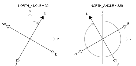
- North direction angle, clockwise from y-axis
- By default, north is located at the top of the window and south at the bottom of the window. Set a new north direction in either of the following ways:
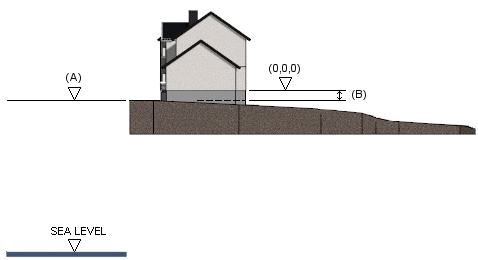
- Altitude
- Enter the height position (A) of the site in relation to the sea level as meters.
- Location (X, Y) relative to model origin
- Enter the site origin distance (mm) from the model origin in x and y axis directions. Enter the distances separated by a comma. You can also click the location of the site origin in the floor plan by clicking Locate. Activate the drawing window before selecting the function Building Coordinates.
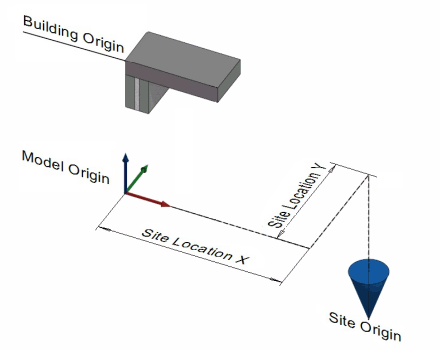
- Site height relative to model origin
- Enter the site origin distance (mm) from the model origin in the z axis direction (B). You can also click the location of the site origin in the model by clicking Locate. Activate the model window before selecting the function Building Coordinates.

- Site origin visible
- Show or hide the site origin. Origin marking in the floor plan:


Building origin
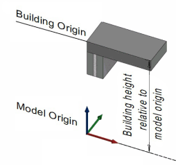
This height information affects the height markings to be added in the building drawings.
- Building height relative to model origin
- Enter the building origin distance (mm) from the model origin in the z axis direction.
- Building origin height
- The text field displays the building origin height (m) relative to the sea level.