
Add Geographical Coordinates
General
- This function allows you to add geographical coordinates to a point in an assembly model.
- If you save the model to an IFC file, the coordinates are also written to the IFC file. The coordinates are written to the origin of the model.
- Geographical coordinates are used for positioning the model when the IFC model is added to applications that use geographical coordinates.
Add Geographical Coordinates
- Select the context-sensitive function Other Function s> Geographical Coordinates.
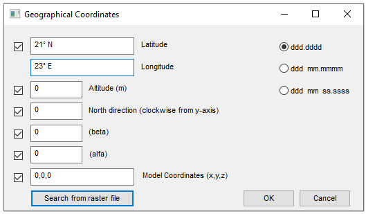
- The program opens the dialog box Geographical Coordinates.
- The program opens the dialog box Geographical Coordinates.
- Select the way you want to enter coordinates
- ddd.dddd = Enter the coordinates in decimals of degree.
- ddd mm.mmmm = Enter the coordinates in degrees and minutes in decimals.
- ddd mm ss.sss = Enter the coordinates in degrees and minutes and seconds in decimals.
- ETRS-TM35FIN = Use the level coordinate system used in Finnish terrain maps.
- Enter the coordinates
- Latitude.
- Longitude.
- Enter the altitude
- As meters above sea level.
- Enter the north direction
- By default, north is located at the top of the window and south at the bottom of the window. To set a new north direction, enter an angle measured clockwise from the positive Y axis in the text field.
- If necessary, enter the Beta and Alfa values
- Beta = ?
- Alfa = ?
- Model coordinates (x,y,z)
- Enter the coordinates of the point corresponding to the geographic coordinate in the model.
- By default, the absolute origin point (0,0,0) of the model is used.
- Search from raster file
- ??